What are Aids to Navigation (ATONs)?
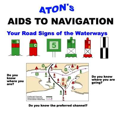
The waters of the United States and its territories are marked to assist navigation by the U.S. Aids to Navigation System (ATON). This system employs a simple arrangement of colors, shapes, numbers, and light characteristics to mark navigable channels, waterways, and adjacent obstructions.
The U.S. Aids to Navigation System is intended for use alongside official nautical charts. Charts are one of the most critical tools used by boaters for planning trips and safely navigating waterways. They indicate the nature and shape of the coast, buoys and beacons, water depths, land features, directional information, marine hazards, and other vital data that cannot be obtained from standard road maps or atlases.
If you operate a vessel in the waters in and around Fort Myers Beach, we strongly encourage you to become familiar with the ATON system. One of the best ways to gain a solid understanding is to enroll in an in-person Boating Safety Course. These programs provide foundational navigation skills and familiarize you with waterway markers. Advanced courses, such as Basic Coastal Navigation and Advanced Coastal Navigation, are also available.
Remember, ATONs are merely an aid to navigation—they do not replace nautical charts, a proper lookout, or common sense. It is easy to run aground in the "skinny" shallow waters of Southwest Florida. Additionally, severe storms and hurricanes can destroy, displace, or alter the light characteristics of waterway markers. The Coast Guard publishes these discrepancies in the District 7 Local Notice to Mariners. Urgent alerts are issued via the Broadcast Notice to Mariners.
Important Navigation Links & Reports:
- Report an Off-Station or Damaged ATON – Notify the USCG Navigation Center directly of damaged or displaced buoys.
- Search Southwest Florida Broadcast Notice to Mariners – Check for real-time navigational hazards and emergency buoy updates.
- District 7 Local Notice to Mariners – Review weekly updates on navigational aids, hazards, and channel conditions.